Watch the grass grow with "SatGrass
Around half of the agricultural land in Austria is grassland: 1.34 million hectares provide the fodder basis for 53,000 domestic livestock farms. The "SatGrass" project is researching how the optimal time for mowing can be determined using satellite data. In addition, this could be used to determine the grassland yield with its annual fluctuations for the different regions of Austria more precisely than before.
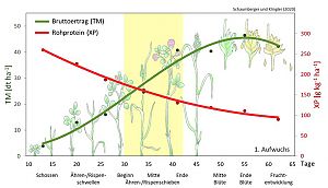
"Finding the optimal time to cut a grassland area is not a trivial task," says Andreas Schaumberger, scientific director of "SatGrass." The reason: the longer the grass grows in a pasture or meadow, the more its quality decreases, as the structures in the plant cells become more pronounced with age. While this process results in increased storage of lignin, the nutrient content and digestibility of the basic forage continually decrease. The forage is richest in protein at the beginning of a growth, but the yield is still low then. This means that the optimal relationship between yield and quality occurs in a time window from when the grasses enter the ear/panicle shoots phase and which lasts until flowering. And it is these time windows that researchers at the Department of Grassland Management and Cultivated Landscape at the Raumberg-Gumpenstein Higher Federal Teaching and Research Institute (HBLFA) in the Upper Styrian Enns Valley, BOKU and TU Vienna, and ZAMG want to determine for potentially every grassland area in Austria using satellite data.
In a self-financed three-year pilot study, the HBLFA team together with researchers from BOKU already proved that it is in principle possible to estimate the development of yield and quality in grassland using sentinel data from the European Copernicus mission. In the follow-up project "SatGrass", which is funded by the Austrian space program ASAP and runs until 2023, the findings will now be deepened and refined by including not just one, but well over 150 sites for the modeling. On board as project coordinators are the Austrian Working Group for Grassland and Livestock (ÖAG) as well as the University of Natural Resources and Applied Life Sciences Vienna (BOKU), the Vienna University of Technology and the Central Institute for Meteorology and Geodynamics (ZAMG). "SatGrass" stands for "Satellite-based modeling of grassland yield and quality dynamics."
Data from space, weather observation and local partners
The high-resolution data from the Sentinel-1 and Sentinel-2 satellite pairs provide an overview of Austria's grassland at intervals of around 5 days. However, satellite measurements can be affected: In radar images from Sentinel-1, soil moisture can lead to distorted data, and in spectral measurements from Sentinel-2, clouds present a barrier. For this reason, "SatGrass" evaluates the satellite images from both systems together and also combines them with weather data such as temperature, radiation and climatic water balance to arrive at meaningful forecasts of the ideal time for cutting. The collected data is compared with measurements on the ground. Over the next two years, the project team will be monitoring around 170 grassland areas in all relevant Austrian climatic regions.
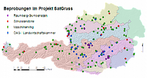
"Maschinenring forms a very important pillar here by providing a dense network of observation sites with around 100 grassland farms," emphasizes Andreas Schaumberger. "Agricultural schools throughout Austria are also important partners, collecting yield data on their land and thus further improving the validity of the models. Sampling is very time-consuming, as data on biomass, quality, growth height and stand are collected not only on harvest dates, but every two weeks, thereby recording the development of the plant stand over the course of a growing season." - Soil data is fed into the project data pool via smartphone app.
Benefits for farms and agricultural policy
If "SatGrass" produces the expected results, new opportunities could open up in the future for farmers as well as for extension and agricultural policy. Andreas Schaumberger: "Estimating yield and quality development in grassland based on satellite and weather data can help farmers choose an optimal cutting time in the future." - And the project is interesting for agricultural policy because grassland yields have so far been recorded on the basis of samples and estimates, which, however, cannot fully cover the diverse influences of different regions and exceptional weather conditions. With meaningful satellite data, yields can be determined with greater accuracy in the future and, above all, the regional influences of climate and weather on yields, particularly drought periods, can be better taken into account.
Project contact
Dr. Andreas Schaumberger
HBLFA Raumberg-Gumpenstein
Institut für Pflanzenbau und Kulturlandschaft
Grünlandmanagement und Kulturlandschaft
Tel.: +43 3682 22451 315
E-Mail: andreas.schaumberger@raumberg-gumpenstein.at