First helicopter flight on Mars takes off with small Austro-participation
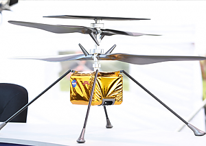
The mini helicopter, which goes by the German name "Einfallsreichtum," weighs just 1.8 kilograms and has already caused quite a stir in the past. In the extremely thin atmosphere, the four rotor blades made of carbon fiber have to rotate much faster than they would on earth. In up to four flight tests, "Ingenuity" is to prove that such flights are possible on Mars.
Orientation in the crater
Using cameras and software developed at the Jet Propulsion Laboratory (JPL) of the California Institute of Technology (Caltech), orientation in the "Jezero Crater" should then be possible. In this way, the topography of the surrounding area will also be recorded. Weiss has been working on the development of systems for this innovative type of orientation and navigation since his dissertation at ETH Zurich. Between 2012 and 2015, he worked on the matter at JPL, where he was able to pursue his ideas further. "Can we fly this on Mars?" asked then-JPL head Charles Elachi after the technology demonstration of his dissertation there, Weiss told APA.
Confidence has grown since then, according to the now head of the Institute for Intelligent System Technologies at Klagenfurt University, who continues to be involved in the sensational project in fortnightly meetings: "We still have our finger on the pulse of development." In recent years, the main goal has been to simplify the system so that it can maneuver on Mars as error-free as possible. At the landing point, the terrain is primarily flat, and the environment offers correspondingly little contrast or distinctive landmarks. This is comparable to a ski slope shortly before dawn, where bumps can hardly be made out from a certain bird's eye view. This is exactly what the algorithm is now optimized for, the researcher explained.
"Nervousness is rising"
The big test far from Earth is getting closer as the landing approaches. "The nervousness is rising," Weiss said. When the first test will be launched is not yet clear, he said. But he expects a good month or two before all the checks are done. "It's a very satisfying feeling" for the Swiss to see such a fundamental research idea actually being implemented on Mars: "Something like this just happens, you can't imagine it or hope for it. Sometimes you're just in the right place at the right time."
Now the scientist and his team are also driving development forward from Klagenfurt. For example, as part of the Mars analog missions "AMADEE-20," which is organized by the Austrian Space Forum (ÖWF). In a Mars-like environment in the desert of Israel, camera-based navigation will also be tested in the "AMAZE" experiment in the fall.
"There are still numerous situations and terrain specifications that mean that currently available algorithms and methods just don't work," Weiss said. This is where data in such challenging environments is needed, he said. "We're in the process of developing novel algorithms in research right now." That's important not only for exploring distant worlds, he said, because there are many situations on Earth, too, where GPS navigation is difficult. The same is true indoors, of course.