Geoinformation for efficient relief operations
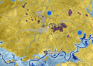
The lack of reliable knowledge about these migration flows poses enormous challenges for aid organizations that have to react spontaneously and quickly. For example, it is not at all uncommon for aid workers to rush to places where there are no refugees at all due to incorrect information, or for twice as many people to have to be cared for instead of the expected 50,000. In addition, the collection of spatial data in the mostly remote camps is extremely difficult and sometimes even dangerous.
Maps, reports, online web services
In order to nevertheless provide aid organizations with the information they need, researchers at the University of Salzburg have developed a method for deriving the necessary geoinformation from earth observation and GIS data. "Our cooperation partners, which for years have included the organization Doctors Without Borders, for example, receive this data within a few days in the form of maps, online web services or reports," explains Stefan Lang of the Interdepartmental Department of Geoinformatics at the University of Salzburg. Since 2011, this information has already enabled Doctors Without Borders to optimize its aid during large refugee movements in Central and East Africa, for example. "From our data, aid workers can find out, for example, where how many people are currently located, how fast the camps are growing, whether and where there are groundwater reserves or areas that can be used for agriculture," says Stefan Lang.
Expanded service
To ensure that other aid organizations can also benefit from this service, the existing range of services was expanded and optimized as part of the EO4HumEn project with financial support from the FFG and in cooperation with the German Aerospace Center DLR. Through the follow-up project EO4HumEn+, also funded by BMK and FFG and running until 2018, refugee flows in urban regions will also be recorded in the future, where population estimates are particularly difficult. "Distinguishing between new arrivals and the local population based on geoinformation is anything but trivial, but it is feasible," the geoinformatician knows. The expanded service is also expected to make things much easier in the area of natural disaster relief. For example, specific geoinformation could be used to support the Red Cross in its disaster relief operations in Central Asia, where spontaneous glacier melt repeatedly causes devastating floods.
European Earth Observation System
The two EO4HumEn projects are a contribution to the large-scale Copernicus Earth observation program, with which the EU aims to create and operate an independent European Earth observation system. Whereas up to now, information has mainly been gathered for environmental and security-related issues, the Salzburg project has now added humanitarian aid as an important new area of application.